-
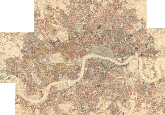
Personalised Poverty Map of London by Charles Booth, 1898-9
Regular price From $0.00Regular price From $0.00 Sale priceUnit price per$151.00100% -
Scotland Clan Map by WH Lizars, 1822: Rare Colour Map of the Highlands of Scotland
Regular price From $0.00Regular price From $0.00 Sale priceUnit price per$45.00100% -


Rare Old Map of Wales by Jean Blaeu, 1645 - from the Theatrum Orbis Terrarum Sive Atlas Novus
Regular price From $0.00Regular price From $0.00 Sale priceUnit price per$45.00100% -


Map of Inverness, Highlands and Moray in 1654, a rare colour old map by Joan Blaeu and Timothy Pont
Regular price From $0.00Regular price From $0.00 Sale priceUnit price per$45.00100% -
Old Map of Edinburgh, Scotland in 1853 by WB Clarke and George Cox - Waverley, Old Town, New Town, Castle, Railway, Arthurs Seat
Regular price From $0.00Regular price From $0.00 Sale priceUnit price per$45.00100% -


Old Map of Bristol in 1750 by John Rocque - Clifton, Kingsdown, Redcliffe, Cathedral City Chart
Regular price From $0.00Regular price From $0.00 Sale priceUnit price per$45.00100% -
Old Map of Newcastle upon Tyne and Gateshead by Thomas Oliver, 1830
Regular price From $23.10Regular price From $23.10 Sale priceUnit price per$35.0034% -
Rare Old Map of London in 1690 by Joannes de Ram
Regular price From $0.00Regular price From $0.00 Sale priceUnit price per$45.00100% -
Old Colour Map of Cambridge and University Colleges, 1575 by Georg Braun - Trinity, Kings, Queens, Clare, Peterhouse, Christ's, Caius
Regular price From $0.00Regular price From $0.00 Sale priceUnit price per$45.00100% -
Custom Old Map of London by C&J Greenwood, 1830
Regular price From $0.00Regular price From $0.00 Sale priceUnit price per$151.00100% -
Custom Old Map of London by John Rocque, 1746
Regular price From $0.00Regular price From $0.00 Sale priceUnit price per$151.00100% -
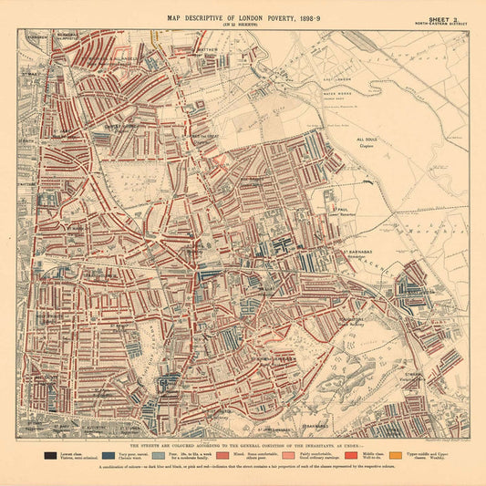
Map of London Poverty 1898-9, North Eastern District, by Charles Booth - Hackney, London Fields, Clapton, Marshes - E5, E8, E9, E3, N16
Regular price From $0.00Regular price From $0.00 Sale priceUnit price per$35.00100% -
Map of London Poverty 1898-9, Northern District, by Charles Booth - Camden, Islington, Stoke Newington, Kings Cross - N1, N1C, N5, N7, N16, N4
Regular price From $0.00Regular price From $0.00 Sale priceUnit price per$35.00100% -
Old Map of London & Suburbs, Environs by G.W. Colton, 1886
Regular price From $0.00Regular price From $0.00 Sale priceUnit price per$35.00100% -
Old map of Kent in 1596 by Philip Symonson - Dartford, Maidstone, Bromley, Tunbridge, Gillingham, Chatham
Regular price From $0.00Regular price From $0.00 Sale priceUnit price per$45.00100% -
Map of London Poverty 1898-9, West Central District, by Charles Booth - Westminster, Camden, City of London, Islington - W1, WC1, WC2, EC1, N1
Regular price From $0.00Regular price From $0.00 Sale priceUnit price per$45.00100% -
Old Pictorial Map of Birmingham in 1730 by Bernard Sleigh
Regular price From $0.00Regular price From $0.00 Sale priceUnit price per$45.00100% -
Old London Map: Mogg's 24 miles around London, 1820
Regular price From $0.00Regular price From $0.00 Sale priceUnit price per$35.00100% -


Old Rail Map of England and Wales, 1883: Letts's Railway & Statistical Map - Train Network Chart
Regular price From $0.00Regular price From $0.00 Sale priceUnit price per$45.00100% -
Map of London Poverty 1898-9, North Western District, by Charles Booth - Camden, Hampstead, Westminster, Regents Park - NW1, NW5, NW3, NW8, NW6, W9
Regular price From $0.00Regular price From $0.00 Sale priceUnit price per$35.00100%