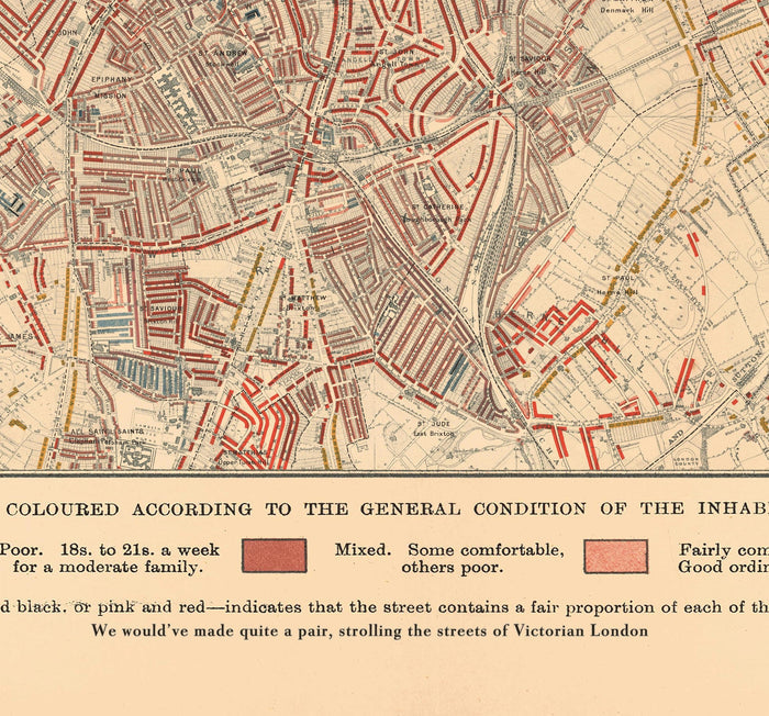
Map of London Poverty 1898-9, West Central District, by Charles Booth - Westminster, Camden, City of London, Islington - W1, WC1, WC2, EC1, N1
Map of London Poverty 1898-9, West Central District, by Charles Booth - Westminster, Camden, City of London, Islington - W1, WC1, WC2, EC1, N1


Couldn't load pickup availability

Map of London Poverty 1898-9, West Central District, by Charles Booth - Westminster, Camden, City of London, Islington - W1, WC1, WC2, EC1, N1
🔒 Order with Confidence
🔒 Order with Confidence
✅30-Day Money Back Guarantee — no risk trying it.
🚚Free shipping available. Orders processed within 24–48 hours.
🔐Secure & encrypted checkout with trusted payment providers.
This is a print of sheet 6 of the Map of London Poverty, created by Charles Booth in 1898-9.
These 12 maps of London were an epic undertaking to map out the various levels of poverty and affluence of everyone in London. These are some of the most detailed historic maps of London ever made.
This map shows the historic West Central District of London, which today is mostly the London boroughs of Westminster and Camden, with parts of City of London and Islington visible. This part of central London hasn't changed much in the past 100 years or so, but it's still interesting to see the large patches of poverty east of Drury Lane/Covent Garden.
This map looks great at all sizes: 12x16 inches (31x41cm), 18x24 inches (45.5x61cm), and 24x30 inches (61x76cm), but it looks even better when printed large.
90cm).
I can create beautiful, large prints of this map up to 56x70 inches (140x180cm). Please get in touch if you're looking for larger, customised or different framing options.
The model in the listing images is holding the 20x16 inch (50x40cm) version of this map.
The fifth listing image shows an example of my map personalisation service.
Please note that the 24x30 inch unframed map has white strips along the edge. These can be easily snipped off, or they may help you with framing. All other sizes, and all framed maps, look just like the listing images.
The level of detail in these maps is breathtaking, with individual houses coloured to show whether they are "vicious semi-criminal" (black); "very poor" (dark blue); "poor" (light blue); "mixed" (red); "fairly comfortable" (light red); "middle class" (bright red); "upper-middle and upper class" (yellow).
This would make a wonderful birthday, Christmas, Father's Day, work leaving or housewarming gift for someone from London or someone who has a keen interest in the history of London.
This map is available as a giclée print on acid free archival matte paper, or you can buy it framed. The frame is a nice, simple black frame that suits most aesthetics. Please get in touch if you'd like a different frame colour or material. My frames are glazed with super-clear museum-grade acrylic (perspex/acrylite), which is significantly less reflective than glass, safer, and will always arrive in perfect condition.