-
Rare Old Map of London in 1690 by Joannes de Ram
Regular price From $0.00Regular price From $0.00 Sale priceUnit price per$45.00100% -
Old Colour Map of Cambridge and University Colleges, 1575 by Georg Braun - Trinity, Kings, Queens, Clare, Peterhouse, Christ's, Caius
Regular price From $0.00Regular price From $0.00 Sale priceUnit price per$45.00100% -
England Face Mask / Neck Gaiter - with vintage geological map of England & Wales by Roderick Impey Murchison, 1843
Regular price $33.75Regular price $33.75 Sale priceUnit price per$45.0025% -
Custom Old Map of London by C&J Greenwood, 1830
Regular price From $0.00Regular price From $0.00 Sale priceUnit price per$151.00100% -
Bath Face Mask / Neck Gaiter with vintage map print of Bath by John Rapkin, 1851
Regular price $35.55Regular price $35.55 Sale priceUnit price per$45.0021% -
Manchester Face Mask / Neck Gaiter with vintage map print of Manchester and Its Environs by John Rapkin, 1851
Regular price $32.40Regular price $32.40 Sale priceUnit price per$45.0028% -
Birmingham Face Mask / Neck Gaiter with vintage map print of Birmingham in 1730
Regular price $27.90Regular price $27.90 Sale priceUnit price per$45.0038% -


London Face Mask / Neck Gaiter with vintage map print of Mogg's 24 miles around London, 1820
Regular price $30.60Regular price $30.60 Sale priceUnit price per$45.0032% -


Designer Face Mask with CUSTOM Historic Map of London (Charles Booth, John Rocque, C&J Greenwood)
Regular price $48.51Regular price $48.51 Sale priceUnit price per$77.0037% -
Oxford Face Mask / Neck Gaiter with vintage map print of Oxford in 1929 by Spencer Hoffman
Regular price $27.45Regular price $27.45 Sale priceUnit price per$45.0039% -
Custom Old Map of London by John Rocque, 1746
Regular price From $0.00Regular price From $0.00 Sale priceUnit price per$151.00100% -
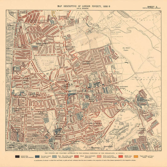
Map of London Poverty 1898-9, North Eastern District, by Charles Booth - Hackney, London Fields, Clapton, Marshes - E5, E8, E9, E3, N16
Regular price From $0.00Regular price From $0.00 Sale priceUnit price per$35.00100% -
Map of London Poverty 1898-9, Northern District, by Charles Booth - Camden, Islington, Stoke Newington, Kings Cross - N1, N1C, N5, N7, N16, N4
Regular price From $0.00Regular price From $0.00 Sale priceUnit price per$35.00100% -
Old Map of London & Suburbs, Environs by G.W. Colton, 1886
Regular price From $0.00Regular price From $0.00 Sale priceUnit price per$35.00100% -
Old map of Kent in 1596 by Philip Symonson - Dartford, Maidstone, Bromley, Tunbridge, Gillingham, Chatham
Regular price From $0.00Regular price From $0.00 Sale priceUnit price per$45.00100% -
Map of London Poverty 1898-9, West Central District, by Charles Booth - Westminster, Camden, City of London, Islington - W1, WC1, WC2, EC1, N1
Regular price From $0.00Regular price From $0.00 Sale priceUnit price per$45.00100% -
Old Pictorial Map of Birmingham in 1730 by Bernard Sleigh
Regular price From $0.00Regular price From $0.00 Sale priceUnit price per$45.00100% -
Old London Map: Mogg's 24 miles around London, 1820
Regular price From $0.00Regular price From $0.00 Sale priceUnit price per$35.00100% -


Old Rail Map of England and Wales, 1883: Letts's Railway & Statistical Map - Train Network Chart
Regular price From $0.00Regular price From $0.00 Sale priceUnit price per$45.00100% -
Map of London Poverty 1898-9, North Western District, by Charles Booth - Camden, Hampstead, Westminster, Regents Park - NW1, NW5, NW3, NW8, NW6, W9
Regular price From $0.00Regular price From $0.00 Sale priceUnit price per$35.00100%