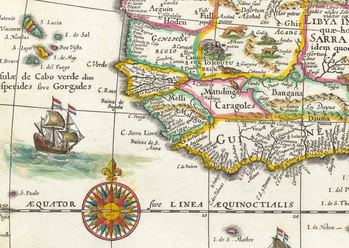
Old Map of Africa by Johannes Blaeu, 1635 - Rare Atlas Colonial Continent Map
Old Map of Africa by Johannes Blaeu, 1635 - Rare Atlas Colonial Continent Map
Excellent 4.9
19,544 Reviews
Trustpilot


465 sold in the past 24 hours
401 people are viewing this item
Only 1% left in stock
Regular price
$35.10
Regular price
$35.10
Sale price
$45.00
Unit price
per
Couldn't load pickup availability

Old Map of Africa by Johannes Blaeu, 1635 - Rare Atlas Colonial Continent Map
Regular price
$35.10
Regular price
$35.10
Sale price
$45.00
Unit price
per
🔒 Order with Confidence
🔒 Order with Confidence
✅30-Day Money Back Guarantee — no risk trying it.
🚚Free shipping available. Orders processed within 24–48 hours.
🔐Secure & encrypted checkout with trusted payment providers.
This is an exceedingly rare full colour map of Africa in 1635, created by master mapmaker Joan Blaeu from his workshop in Amsterdam and originally published in this Theatrum Orbis Terrarum Sive Atlas Novus.
This is the best and most iconic map of the African continent from the 17th century. A must-have addition to any collector of world maps.
This map looks great at all sizes: 12x16 inches (31x41cm), 18x24 inches (45.5x61cm) and 24x36 inches (61x91.5cm), but it looks even better when printed large.
I can create beautiful, large prints of this map up to 52x70 inches (130x180cm). Please get in touch if you're looking for larger, customised or different framing options.
The model in the listing images is holding the 24x18 inch (61x45.5cm) version of this map.
If you’re looking for more options, I have another interesting Africa map by Emanuel Bowen in 1747.
This map was created back when cartographers knew relatively little about Africa, and this map is full of inaccuracies. Blaeu consulted many other maps of Africa to create this one - and those source maps themselves were inaccurate.
Back then, it was believed that the source of the Nile was the Mountains of the Moon (Lunae Montes on this map), a theory from Ptolemy's time (100AD in Egypt).
Back in medieval times Latin was the language of maps, and most of the place names on this map are in Latin. Many of the countries and political divisions are still easily recognisable though, such as Aegyptus (Egypt), Arabia and Zanzibar.
This would make a wonderful birthday, Christmas, Father's Day, work leaving or housewarming gift for someone from Africa, or someone who has Africa close to their heart.
This map is available as a giclée print on acid free archival matte paper, or you can buy it framed. The frame is a nice, simple black frame that suits most aesthetics. Please get in touch if you'd like a different frame colour or material. My frames are glazed with super-clear museum-grade acrylic (perspex/acrylite), which is significantly less reflective than glass, safer, and will always arrive in perfect condition.
View full details
This is the best and most iconic map of the African continent from the 17th century. A must-have addition to any collector of world maps.
This map looks great at all sizes: 12x16 inches (31x41cm), 18x24 inches (45.5x61cm) and 24x36 inches (61x91.5cm), but it looks even better when printed large.
I can create beautiful, large prints of this map up to 52x70 inches (130x180cm). Please get in touch if you're looking for larger, customised or different framing options.
The model in the listing images is holding the 24x18 inch (61x45.5cm) version of this map.
If you’re looking for more options, I have another interesting Africa map by Emanuel Bowen in 1747.
This map was created back when cartographers knew relatively little about Africa, and this map is full of inaccuracies. Blaeu consulted many other maps of Africa to create this one - and those source maps themselves were inaccurate.
Back then, it was believed that the source of the Nile was the Mountains of the Moon (Lunae Montes on this map), a theory from Ptolemy's time (100AD in Egypt).
Back in medieval times Latin was the language of maps, and most of the place names on this map are in Latin. Many of the countries and political divisions are still easily recognisable though, such as Aegyptus (Egypt), Arabia and Zanzibar.
This would make a wonderful birthday, Christmas, Father's Day, work leaving or housewarming gift for someone from Africa, or someone who has Africa close to their heart.
This map is available as a giclée print on acid free archival matte paper, or you can buy it framed. The frame is a nice, simple black frame that suits most aesthetics. Please get in touch if you'd like a different frame colour or material. My frames are glazed with super-clear museum-grade acrylic (perspex/acrylite), which is significantly less reflective than glass, safer, and will always arrive in perfect condition.